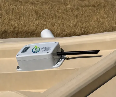
Know a crossing is going under before someone drives into it.
Low-water crossings flood fast, and most are unwatched until someone is already in the water. Meterra puts a wireless level sensor on a crossing, culvert, or creek and sends a rising-water alert the moment it climbs past the depth you set — so a road crew, dispatcher, or emergency manager can close the road and warn people while there's still time, instead of after.
The crossing nobody is watching
A low-water crossing is fine 360 days a year and deadly on the other five. Water comes up faster than people expect, often from rain that fell miles upstream, and the crossing is usually unwatched — the first anyone knows is a stranded vehicle or worse. Road departments can’t station a person at every crossing, and a sign that says “do not enter when flooded” only works if someone is there to see the water.
A sensor closes that gap. It sits at the crossing, watches the level around the clock, and the moment the water climbs past the depth you’ve set as unsafe — or rises unusually fast — it pages the people who can act. Minutes of warning are the difference between a barricade and a rescue.
What Meterra watches
- Low-water crossings and bridges — level at the road, with a threshold alert and a rate-of-rise alert.
- Culverts and drainage channels — catch a blockage or a surcharge before it backs onto the road.
- Creeks and streams — an upstream reading buys downstream warning time.
- Retention and detention basins — confirm capacity and catch an overflow.
Each site reports level and trend to one dashboard, alerts by app and supported channels, gives multi-user access to road crews, dispatch, and emergency management, and exports its full history to CSV for after-event review and mitigation planning.
Built for the field
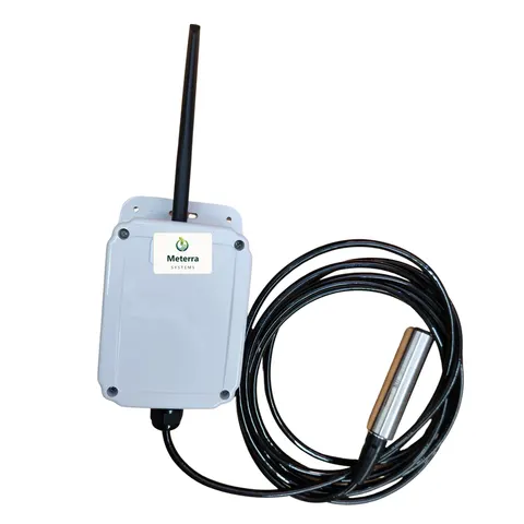
No power, no Wi-Fi, no hub. Sensors run on battery or solar, install in minutes, and report over Verizon’s NB-IoT low-power cellular network, with LEO satellite for crossings that have no cell coverage at all — confirmed per site before install. Open water uses a submerged pressure sensor; a non-contact ultrasonic sensor can read the surface from a bridge or structure above.
Funding help
Flood early-warning and mitigation work is frequently grant-supported. Many communities fund it through FEMA hazard-mitigation programs such as BRIC (Building Resilient Infrastructure and Communities) and the Hazard Mitigation Grant Program, often routed through state emergency management. See our Grants & Funding page for the full list. Allowable costs and eligibility are set by each program — confirm before you count on it.
A note on what this is and isn’t
Meterra provides situational awareness and early warning to support local decisions. It is not a substitute for official National Weather Service warnings, a certified hydrologic gauge network, or on-scene judgment, and it does not control gates, barricades, or signals. No one should ever drive into a flooded crossing, monitored or not.
Getting started
Start with the one or two crossings that worry your community most — the ones with a history, or the school-bus route. Tell us the locations and the coverage there, and we’ll set a pilot and the alert thresholds with you.
The hardware for this job
Every device reports to the same Meterra dashboard and app.
Tell us your site and we'll map the right sensors and coverage.
Frequently asked questions
How does a low-water-crossing sensor work?
A wireless sensor at the crossing measures the water level continuously and reports it to a dashboard. You set a threshold — the depth at which the road becomes unsafe — and the sensor sends an alert the moment the water climbs past it, and again on a fast rate of rise. That gives a road department or emergency manager minutes that matter to close the crossing and warn drivers, instead of finding out from a stranded vehicle.
Is this a certified flood-warning system?
No, and we're careful about that. Meterra provides situational awareness and early warning to support local decisions. It is not a substitute for National Weather Service warnings, a certified hydrologic gauge network, or on-scene judgment — and no one should ever drive into a flooded crossing. It's an affordable extra set of eyes on the specific crossings and culverts your community worries about.
Can it work where there's no power or cell tower at the crossing?
Usually. Sensors are battery or solar powered and install in minutes with no wiring or hub. Primary connectivity is Verizon's NB-IoT low-power cellular network, used for most sites; for crossings with no cellular coverage, low-earth-orbit (LEO) satellite is the alternative. Coverage is confirmed for the specific location before install.
Who gets the alerts, and can we see history?
Multi-user access lets road crews, dispatch, and emergency management each see the crossings relevant to them and receive alerts by app and supported channels. Every site's level history exports to CSV, so you can review an event afterward, document recurring problem crossings, and support planning and mitigation requests.
What can we monitor besides crossings?
The same sensors watch culverts, creeks and streams, stormwater retention and detention basins, and drainage channels. Open water uses a submerged pressure sensor; a non-contact ultrasonic sensor can read the surface from a bridge or structure above. Both report to one dashboard.
How much does it cost, and can grants help?
In our US rollout, sensors start at $299 for the Tank Level Sensor and $499 for the Dam Level Monitor, each including three months of connectivity and full app access; connectivity is then from $10/month per device, with discounts on annual subscriptions. Flood early-warning and mitigation work is often grant-supported — many communities use FEMA hazard-mitigation programs (such as BRIC and the Hazard Mitigation Grant Program). Confirm eligibility with the program. Tell us your crossings and we'll size it.
Related Meterra solutions
- Fire Districts & Wildfire Agencies: the same remote, exportable monitoring for public-safety agencies.
- Water Level Monitoring: how remote, non-contact level sensing works across all water.
- Pond & Dam Monitoring: open-water level sensing, low and high alarms.
- Dam Level Monitor: the submerged pressure sensor for creeks, culverts, and basins.
- Water Districts: storage and infrastructure monitoring for local systems.